
Wildfire Interdisciplinary Research Center (WIRC)
February 01, 2026
Kate Wilkin1,2, Amanda Stasiewicz1,3, Bo Yang1,4, David Benterou1,2, Jack Stevens1,2, Henri Brillon1,2
1 Wildfire Interdisciplinary Research Center (WIRC)
2 San José State University
3 University of Oregon
4University of California Santa Cruz
“Home insurers want to know what mitigations matter most in increasing the safety of homes and communities and if residents are willing and able to carry them out. WIRC’s research provides data that will inform insurers and local authorities on effective mitigations that residents can actually achieve.” Quote by Albert Simeoni, Professor and Department Head of Fire Protection Engineering at Worcester Polytechnic Institute, and Site Director for the Wildfire Interdisciplinary Research Center, a National Science Foundation Industry University Collaborative Research Center.
Introduction
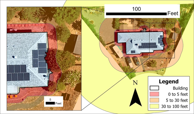
Structural losses from wildfires are increasing in California, the United States, and globally. Research shows that fuel (e.g., flammable materials ranging from natural vegetation to synthetic building materials) in, on, or within 100 feet of structures contributes to structure loss or damage from wildfire; this focal area is often called the Home Ignition Zone (HIZ). Wildfire structure ignitions can be reduced if residents reduce hazards associated with their home that increase the likelihood of ember ignition (e.g., by enclosing eaves, installing vent screens with ⅛-inch mesh, and using less flammable building materials) and reducing flammable fuels around their home (e.g., live and dead vegetation) to create defensible space. Residents within the wildfire urban interface (WUI) often want to mitigate wildfire hazards, but often fall short of the complete risk reduction outlined by state or professional entities.
Working with our Wildfire Interdisciplinary Research Center (WIRC) industry advisory board members who funded and helped design this research (four related projects over four years), we investigated whether residents within the WUI had implemented the HIZ mitigations required or recommended by local laws (compulsory) or national programs (e.g., Firewise, Insurance Institute for Business & Home Safety Wildfire Prepared Homes; voluntary) and, if not, (1) what barriers to completion existed and (2) what solutions were needed. Furthermore, we tested new remote sensing technologies to determine if they were good monitoring tools.
Methods
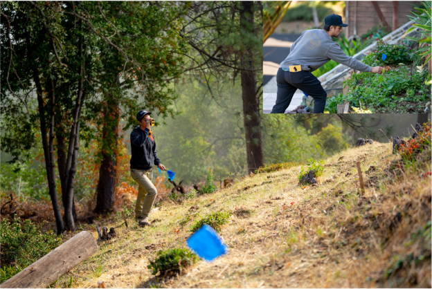
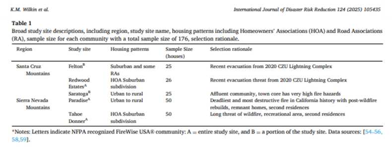
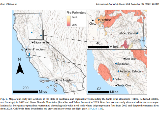
This work was conducted in five sites in the Santa Cruz and Sierra Nevada Mountains in California that were likely to have a high motivation for wildfire mitigation, represented a continuum between rural and urban areas, and where state defensible space laws applied (Table 1 and Figure 1). To investigate compliance, we started with boots-on-the-ground home inspections to assess resident HIZ and defensible space practices, then tested remote sensing options (drones and airborne LiDAR (Laser Detecting and Range Finding)) to scale compliance monitoring. To investigate barriers to implementing mitigations, we used interviews with residents and area professionals involved in fire education or code enforcement to explore participants’ rationales and influences for taking HIZ mitigation action.
Knowledge Gained
Most residences had little compulsory or recommended mitigations completed, and few mitigated 80% of items to meet a “harm reduction” threshold. Participants struggled with hazards that required frequent maintenance. Some hazards that, if present, were not well mitigated include woodpiles; propane tanks; trees and shrubs; and roof, gutter, and deck debris. We explored why some common maintenance issues occurred. For example, debris on roofs and in gutters was most influenced by canopy cover, and to a lesser extent by materials. Smooth metal roofs shed debris better than clay tiles or asphalt shingles. Gutter debris guards lowered the debris probability in gutters, including on gutter guards. While we document much lower rates of mitigation compliance amongst residents than agencies and self-reported research, our findings are similar to those of others with independent inspectors or even resident self-reporting.
Barriers to residents mitigating property-level hazards are numerous and vary across socio-ecological contexts including individual ability to implement mitigations (e.g., physical ability, time, money), trade-offs with other values (e.g., erosion control, shade/energy use, aesthetics), perceived efficacy of the mitigations (including concerns about spillover effects from adjacent properties), and social and cultural norms. These challenges reflect a need for standards that account for local context. For example, many residents surveyed in the Santa Cruz Mountains felt that tree removal and spacing requirements were incompatible with slope stabilization, the need for riparian corridors, and the protected status of species (e.g., redwoods, oaks) (Stasiewicz et al. in preparation).
Drones complement ground-inspections to monitoring mitigation compliance and hazard reduction by providing residence-specific information much faster and with more standardized results than traditional house-to-house inspections on foot (Figure 2, (Brillon et al. in review)). Drones can also identify more hazards than people on the ground, e.g., rooftop hazards that require a birds-eye view, and the entire mapping process and much of the analysis can be automated using geographic information systems (GIS). Airplane and satellite data are being used for similar analyses, but their spatial resolution is still not high enough to accurately delineate the 0-5 foot zone or detect small features, and they are very expensive because their models are proprietary and rely on flying full-size air or space vehicles. Airplane-based LiDAR data is promising to increase the detection of understory vegetation, buildings, and other features (Stevens et al. in preparation). However, data availability is still limited.
Policy Relevance
Overall, policies and research would benefit from more consistency across mitigation programs, clarifying and/or decoupling mitigations, and standardized evaluations. Moving forward, we recommend “mitigating the need to mitigate” since most residents struggled to keep up with maintenance-related mitigations. Residents need guidance on the “mitigations that matter most” and the trade-offs between different mitigation options (e.g., Vulcan vents versus 1/8-inch mesh) to prioritize mitigations and project order (Stasiewicz et al. in preparation). State and local agencies and industry should strive to provide residents with consistent, science-based guidance on how to reduce wildfire risk in the WUI, while also accounting for local context that could otherwise challenge implementation.
Citations
Brillon et al. (in review) Inspecting residential wildfire hazard mitigation policies using Uncrewed Aerial Vehicles and object-based machine learning methods in California’s Wildland Urban Interface
Stasiewicz et al. (in preparation) Towards wildfire risk mitigation in high-risk areas: examining barriers to wildfire risk mitigation in Santa Cruz and Santa Clara Counties, California, USA
Stevens et al. (in preparation) LiDAR shows promise for monitoring defensible space hazards
Wilkin, K. M., Benterou, D., & Stasiewicz, A. M. (2025). High fire hazard Wildland Urban Interface (WUI) residences in California lack voluntary and mandated wildfire risk mitigation compliance in Home Ignition Zones. International Journal of Disaster Risk Reduction, 124, 105435. https://doi.org/10.1016/j.ijdrr.2025.105435